Yucatan Peninsula, Mexico
Coba's distinct character originates from its vastness, its jungle location, and the impressive structures that narrate stories of an once-flourishing metropolis. Visitors frequently describe their time here as a high point of their Yucatán journey, an opportunity to step back from the contemporary world and connect with a rich past.
Coba provides a different facet of Mayan history, situated inland rather than on the coast. Its sprawling layout offers a sense of true discovery. The journey inland from the coast reveals traditional Mayan villages and diverse landscapes, setting the scene for an encounter with the ancient world.
The transition from beaches to deep jungle greens prepares you for the historical depth you are about to explore. Coba remains an accessible historical site for a broad spectrum of travelers.
Coba, an ancient Mayan city, is located in the eastern part of the Yucatán Peninsula, within the Mexican state of Quintana Roo. The site is approximately 47 kilometers (29 miles) inland from the Caribbean coast, positioned northwest of the modern town of Tulum. This inland placement means dense jungle surrounds Coba, a prominent contrast to the coastal areas many visitors experience. Several natural lagoons, including Cobá Lagoon to the south and Macanxoc Lagoon to the east, surround the site.
Coba's geographical position presented a clear benefit to its ancient inhabitants. It enabled control over useful trade routes, specifically those extending towards the Caribbean coast. This eased the movement of goods and resources across the region. This strategic location contributed to Coba's might and standing among Mayan cities. The lush jungle environment also provided natural resources and a degree of natural protection, shaping the city's growth and long-term existence.
A relatively short and direct drive from Tulum.
Readily accessible from Playa del Carmen or Cancún, despite inland location.
Roads leading to Coba are generally well-maintained.
The journey passes through traditional Mayan villages and changing landscapes.
Consider a physical map or downloading offline maps; local exploration is easier with reliable navigation.
The city was not isolated but a pivotal point in a vast network, linked by its famous "sacbes," or white roads, which stretched across the landscape. These roads underscore the Maya's advanced grasp of engineering and urban planning. The surrounding lagoons not only supplied water but also constituted parts of the city's natural boundaries and trade network.
The journey to Coba frequently begins from popular coastal towns. From Tulum, the drive is relatively short and direct. From Playa del Carmen or Cancún, the journey is longer yet straightforward. This makes Coba an accessible historical site for a broad range of travelers.
The shift from bright, sandy beaches to the deep green of the jungle establishes the scene for the ancient world awaiting discovery. Coba's distance from the coast also protected it from some coastal challenges, allowing it to develop as a major inland power.
This strategic location contributed to Coba's influence among Mayan cities. Its inland setting offers a peaceful retreat, demonstrating a different aspect of the Yucatán Peninsula's rich offerings. The atmosphere in Coba village, while simple, adds to the authentic local experience.
Coba, a name translating to "waters stirred by wind" or "ruffled waters" in Yucatec Maya, functioned as a prominent Mayan city during the Classic Period, from approximately AD 250 to 900. At its height, Coba's population likely reached around 50,000 inhabitants. The city spanned an extensive area of approximately 80 square kilometers (30 sq mi), positioning Coba as one of the largest and most powerful Mayan cities in the northern Yucatán Peninsula during its prime. Its size and influence paralleled those of other major hubs like Chichen Itza and Uxmal.
The city's power arose from its careful command over trade routes and agricultural lands. Coba was specifically known for its extensive network of sacbes. These elevated causeways, or white roads, built from limestone. Archaeologists have documented at least 50 such roads fanning out from Coba's core. These roads linked the main city to outlying settlements and other major Mayan cities across the peninsula.
The longest sacbe extends over 100 kilometers (62 miles), linking Coba to the distant site of Yaxuna.
Coba's layout involves groups of structures connected by sacbes, allowing gradual expansion.
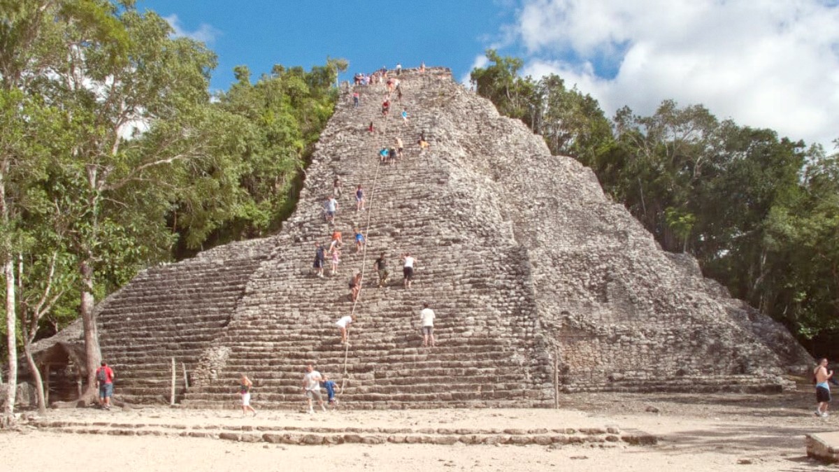
At 42 meters (137 feet), it is one of the tallest Mayan structures in the northern Yucatán.
These remarkable roads were well-built arteries that facilitated the movement of people, goods, and ideas, solidifying Coba's standing as a regional center. Coba's urban plan reflects its intricate society. The city functions as a collection of substantial structure groups spread across the jungle, linked by the sacbes.
Coba features structures spread across kilometers of forest, connected by ancient roads.
Unlike coastal ruins, Coba is immersed in dense jungle, offering a distinct exploration.
Bicycle rentals or tricycle taxis aid in site navigation, connecting visitors to its history.
A deep dive into Mayan history and natural splendor, away from the immediate coastal bustle.
Coba's location permits a quiet, immersive experience, showing a different facet of the Yucatán.
The simple yet authentic atmosphere of Coba village adds to the local experience.
