MileHacker Logo
Local Transportation

Local Transportation

Tabasco And Chiapas, Mexico

Public Transportation: Colectivos

The main form of public transportation within Palenque is the "colectivo," which are shared passenger vans. They offer an efficient and inexpensive way to travel popular routes. Palenque does not have a comprehensive network of city buses or a metro system. Colectivos fulfill this role, operating on fixed routes but without strict schedules, departing when full.

Fares are paid directly to the driver upon boarding or exiting. They are fixed for specific routes. Always have small bills or coins available, as drivers may not carry much change. Colectivos for the Palenque ruins run very frequently from early morning (around 6:00 AM) until late afternoon or early evening (around 6:00 PM). They depart once the van fills up, which usually happens quickly on popular routes.

Colectivo Routes & Tips

  • Town to Ruins (Carretera Ruinas): Colectivos constantly run between Palenque town center and the archaeological site. Look for them near Parque Central or on Calle Juárez.
  • Town to Waterfalls: Colectivos can be arranged for Misol-Ha and Agua Azul. For Roberto Barrios, smaller colectivos or shared taxis may be available.
  • Accessibility: Colectivos are standard vans and are not generally wheelchair accessible.
  • Tips: Ask locals for pick-up spots. State your destination clearly. Be prepared for a short wait until the van fills.

Main Hubs

Parque Central or Calle Juárez in town for ruins and waterfall colectivos.

Fare Payment

Pay directly to the driver with small bills or coins.

Cost-Effective

Colectivos are the most authentic and cost-effective way to move around Palenque.

Taxis & Ride-Sharing

Taxi Services
  • Availability: Taxis are throughout Palenque town and near major tourist attractions.
  • Negotiate Fares: Palenque taxis do not use meters. Agree on the fare with the driver before your ride.
  • Payment: Most taxis are cash-only. Have small bills ready.
Ride-Sharing & Safety
  • Ride-Sharing Apps: Major apps like Uber or DiDi are generally not available or widely used in Palenque.
  • Safety: Use official, licensed taxis. Confirm the price before getting into the taxi to avoid disagreements.
  • Airport/Station Taxis: Taxis are available outside PQM terminal and ADO bus terminal.

Rental Options

Car Rental

Limited agencies in Palenque. Better options at Villahermosa (VSA) or Tuxtla Gutiérrez (TGZ) airports.

Requirements

Valid driver's license (IDP recommended), credit card for deposit, mandatory Mexican car insurance.

Motorcycle/Scooter

Less common. Exercise extreme caution due to road conditions. Helmets are legally required.

Bicycle Rentals

No formal sharing programs. Some hotels offer rentals for local use, especially along Carretera Ruinas.

Walking & Cycling

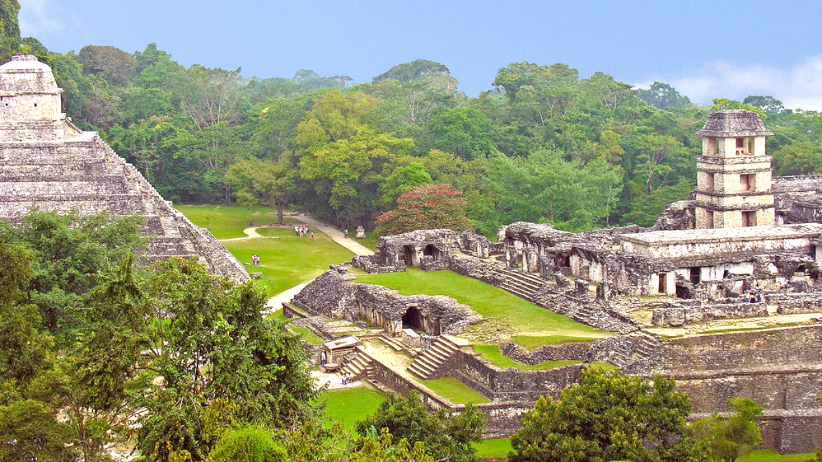
Exploring Palenque on foot or by bicycle offers unique perspectives, especially within the town and around the archaeological zone.

Pedestrian-Friendly Areas

  • Palenque Town Center: Compact and walkable. Easily stroll around the main park, local shops, restaurants, and the ADO bus terminal.
  • Carretera Ruinas: The road to the ruins has sidewalks for portions. Walking the entire way is less common due to heat and distance.
  • Archaeological Site: Designated walking paths lead through excavated ruins and into the surrounding jungle.
  • Wear comfortable, supportive shoes for all walking activities. Uneven surfaces at the ruins and potential mud make good footwear important.

Walking Tour Options & Safety

  • Guided Tours: Guided jungle walks around the ruins area or into nearby forest sections are available from local agencies.
  • Self-Guided: The archaeological site is easily explored independently, though a guide deepens understanding.
  • Cycling Safety: Dedicated bike infrastructure is limited. Cycling on main roads can be hazardous due to traffic and unmarked speed bumps. Stick to less trafficked roads.
  • No-Go Areas: Avoid walking or cycling on unlit roads outside of the town center at night. Do not venture off marked jungle trails without an experienced guide.

Specialized Transportation

  • Tour Buses: Palenque lacks hop-on-hop-off services. Local agencies offer organized day trips via minivans or small buses to ruins and waterfalls.
  • Boat Transportation: Not applicable for local transit. Lanchas operate on the Usumacinta River for excursions to Yaxchilan and border crossings to Guatemala.
  • Accessibility: Infrastructure for mobility challenges is limited. The archaeological site has uneven terrain and stairs, posing difficulties for wheelchair users. Public transport is not accessible.
  • Unique Local Transport: Palenque does not feature cable cars, funiculars, or highly unique local transport systems like tuk-tuks or jeepneys.
  • Yaxchilan/Bonampak Tours: Joining an organized tour is the most practical and safest option due to remote location and river transport needs.
  • Inquire directly about accessibility features and limitations when booking tours or accommodations.

Driving & Parking Information

Driving Laws

Drive on the right. Seatbelts are mandatory. Speed limits vary; observe signage.

Road Conditions

Main highways are paved. Rural roads can be rough with potholes and unmarked speed bumps ("topes").

Parking

Available at major attractions and most accommodations. Street parking or paid lots are options in town.

Local Transportation Takeaways

A quick summary of Palenque's local travel options.

Colectivos: The Local Choice

  • Shared passenger vans are the main public transit.
  • Inexpensive and efficient for popular routes like town-to-ruins.
  • Run frequently during daylight hours.
  • Great for authentic local experience.

Taxis & Rentals: Flexibility

  • Taxis offer convenience but require fare negotiation.
  • Ride-sharing apps are not common here.
  • Car rentals are best arranged at larger airports (VSA/TGZ) for Chiapas exploration.
  • Always use licensed taxis and confirm prices beforehand.

Activities & Safety

Walking

Town center and archaeological site paths are pedestrian-friendly.

Wear comfortable shoes!

Cycling

Limited bike lanes. Stick to less trafficked routes for safety.

Be cautious on roads.

Tour Vans

Convenient for organized trips to distant sites (Yaxchilan, Bonampak).

Most practical for remote sites.

Essential Driving Advice

Road Conditions & Hazards
  • Roads outside main highways can be rough and winding.
  • Watch for unmarked speed bumps ("topes").
  • Avoid driving at night on rural roads due to poor visibility.
Permits & Insurance
  • International Driving Permit is a good supplementary document.
  • Mandatory Mexican car insurance is purchased separately.
  • GPS navigation can be inconsistent in remote areas.

Important Considerations for Mobility

Challenges for Mobility Needs
  • The archaeological site has uneven terrain, numerous stairs, and no ramps.
  • Public transport (colectivos) are not wheelchair accessible.
  • Limited infrastructure for travelers with mobility challenges.
Planning for Accessibility
  • Inquire directly with hotels and tour operators about specific accessibility features.
  • Manage expectations and plan your itinerary accordingly.
  • Prioritize accommodations and activities that confirm accessibility.

Local Travel Insights

For more remote or complex destinations, organized tours usually offer the best logistical support and safety.